Thomas Holdsworth Poppleton and
the Surveyor’s Map that Made Baltimore,
or a story of minor intrigue and not so professional rivalry
in the City of Promise
by
Edward C. Papenfuse, Maryland State Archivist, retired[1]

Figure 1, Poppleton’s Map of Baltimore, 1822, courtesy of
the Library of Congress, Geography and Map Division
http://hdl.loc.gov/loc.gmd/
In 1822 Thomas Holdsworth Poppleton published his large wall map of the City of Baltimore based upon a multi-year survey that he completed the previous year. On December 31, 1796, three areas, the original town, Fell’s Point, and Old Town, to the east of Jones Falls, were merged into one with a new City charter, but there was as yet no clear definition of the outward boundaries of the resulting City.[2]
Thomas Poppleton placed the earliest known manucript survey of the original town, completed by Philip Jones in 1730, near the center of his map and colored it lightly in red.

Figure 2, Baltimore “old town” outlined and faintly shaded red on Poppleton’s map, 1822,
Library of Congress Geography and Map Division
Prior to Poppleton’s map there had been two efforts to publish a map of the town, A. P. Folie’s 1792 wall map, which depicted the growth of all three communities that would be united four years later into Baltimore City, and Charles Varlé’s topographical map which was completed about 1797, and appeared as a reprint by Warner and Hanna in 1801.[3]
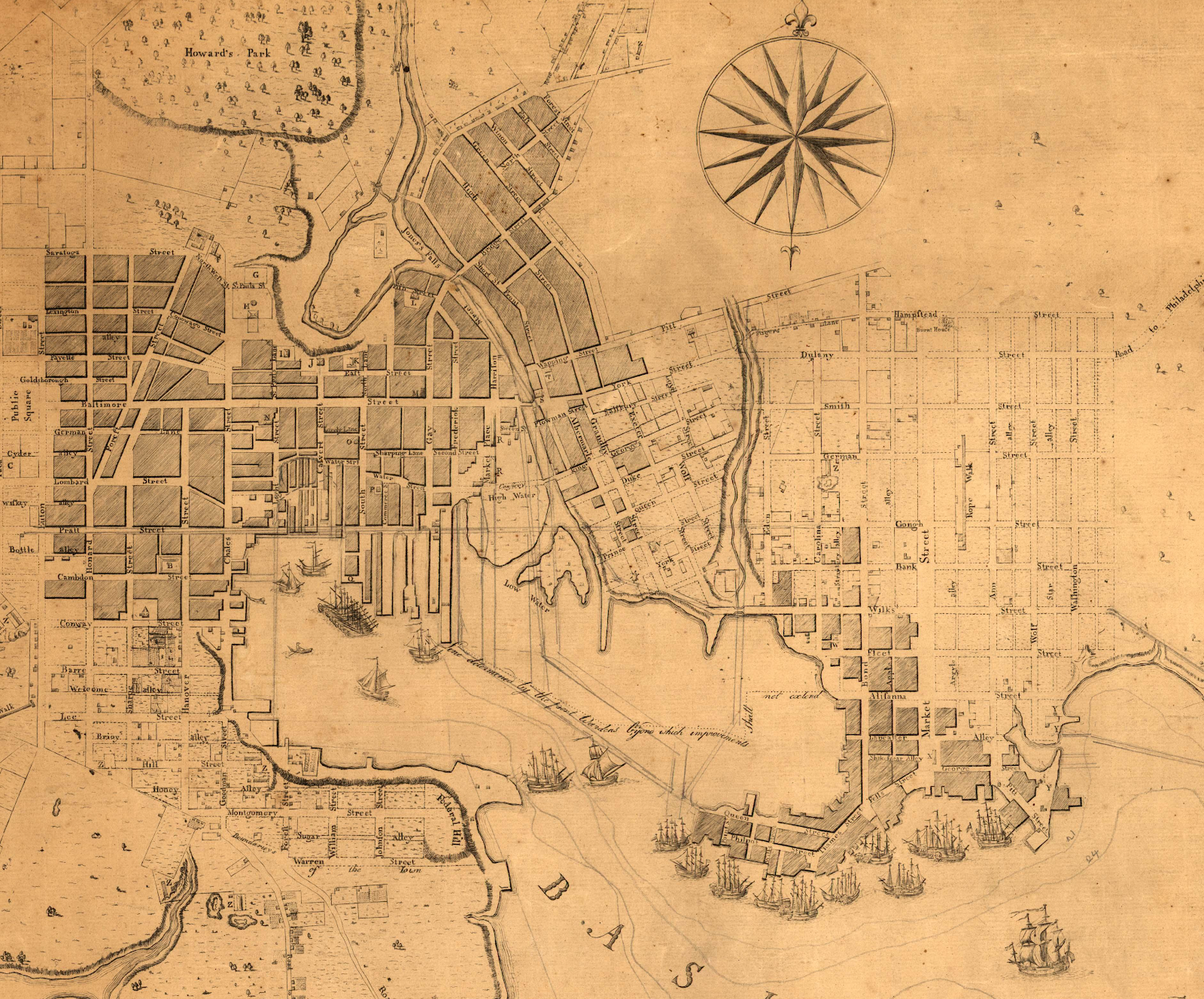
Figure 3, Detail from A. P. Folie, Plan of the Town of Baltimore, 1792, Library of Congress
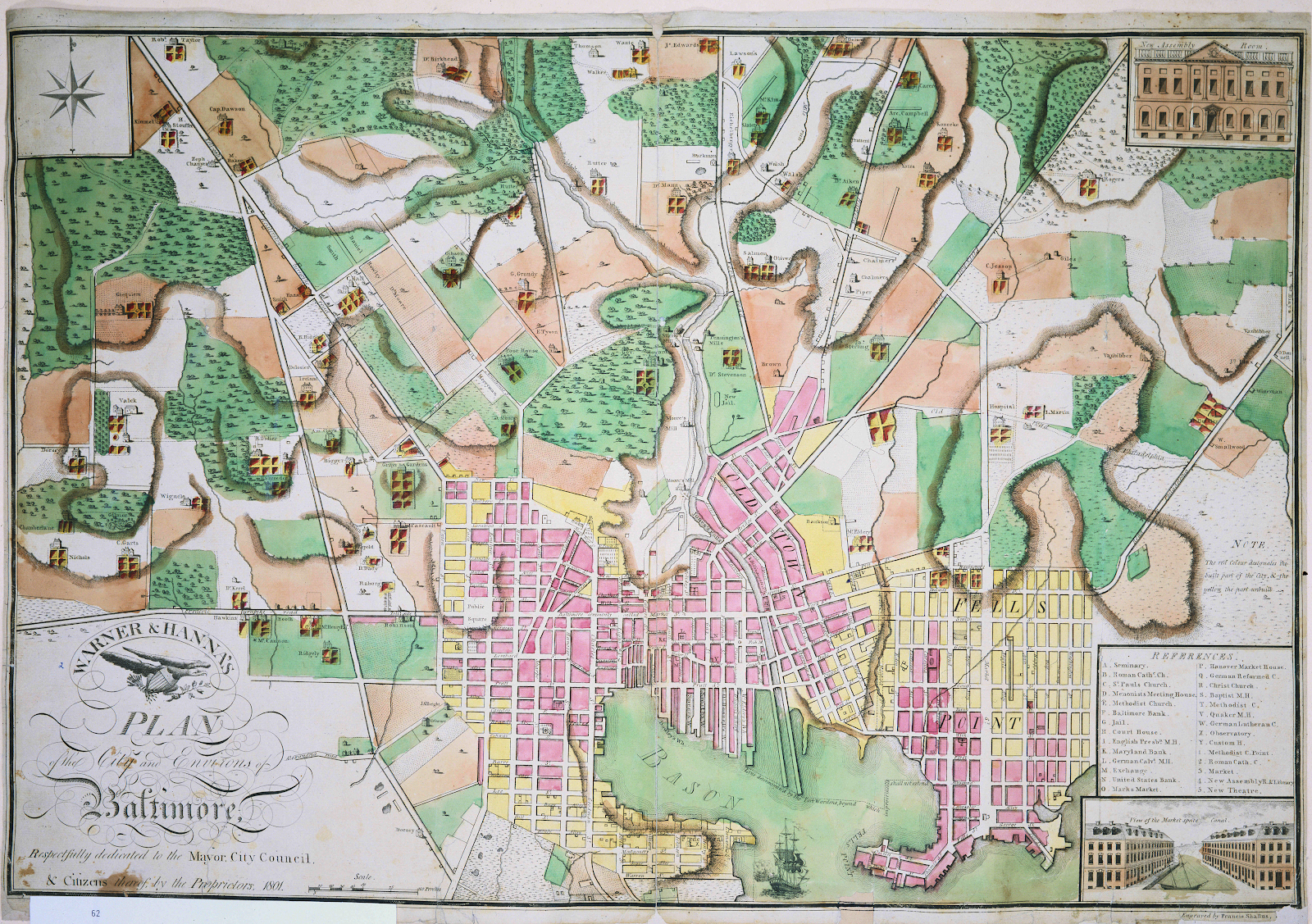
Figure 4, [Charles Varlé], Warner & Hanna’s Plan of the City and Environs of Baltimore, 1801, Peabody Library Collection of the Johns Hopkins University, MSA SC 1213-1-172
Until 1822 the outer boundaries of the City remained unmapped without clearly defined and marked lines. The City’s jurisdiction was expanded in law to include Eastern and Western precincts, but the streets and property lines throughout lacked all but vague verbal descriptions. Then, in February 1817 by legislative fiat of the Maryland General Assembly, the official boundaries of Baltimore City were enlarged to encompass 14.71 square miles, with instructions that an accurate survey should be undertaken.[4]
From 1776 until 1820, the resident population of what was vaguely defined as Baltimore City in 1796, grew from about 6,000 to 63,000, of whom over 14,000 were slave and free blacks. In that period, as Sherry Olson and David Head point out, commerce was the mainspring of the City’s economy. It was fed by the constant stream of shipping in and out of the port, most of it legal, but some of it the product of piracy, and, as the City entered the 1820s, in its most adventuresome mode, it became dependent upon illegally feeding the revolutions in Central and South America as well as clandestine participation in the illegal transatlantic slave trade. Baltimore was a haven for risk taking merchants and sea captains, who with other townsfolk, also speculated in bank stock, precipitating a deep depression that lasted from 1817 to about 1822 ruining many of the commercial high rollers in Baltimore and elsewhere. Business losses, however did not impede the optimism of the City developers. They needed a map on which to build and Thomas Holdsworth Poppleton would be called upon twice to provide one.[5]
To land surveyors the decades between the American Revolution and the end of the War of 1812 were profitable sorting out who actually owned what property in town, including where the wharfs, streets and alleys should run amidst the building boom prior to the financial collapse. In 1784 the legislature tried to impose some order on the chaos by requiring that a correct survey of the City be made. As an 1812 City ordinance pointed out, it was never carried into execution.[6]
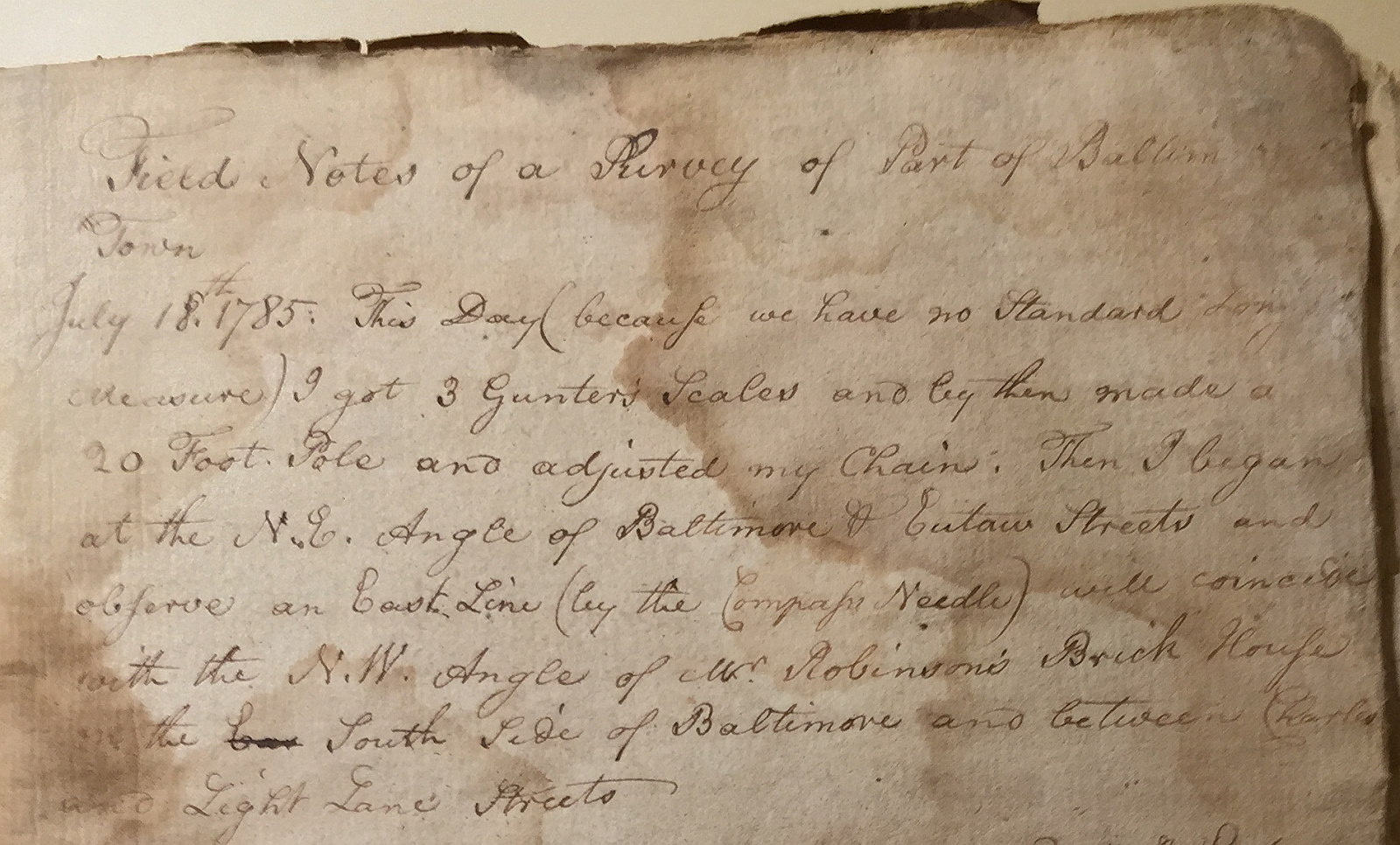
Figure 5, Maryland Historical Society, Cornelius Howard Papers 1659-1853,
MS. 469.5, Box 2, Field Notes of a Survey of a Part of Baltimore Town (1 vol.), 1785-86
A fragment of surveyors notes has survived, indicating that a valiant attempt was undertaken to conduct an accurate survey, probably by Cornelius Howard, but no detailed large scale map emerged until after the City began to tackle the task on the eve of the Second American War of Independence, better known as the War of 1812.[7]
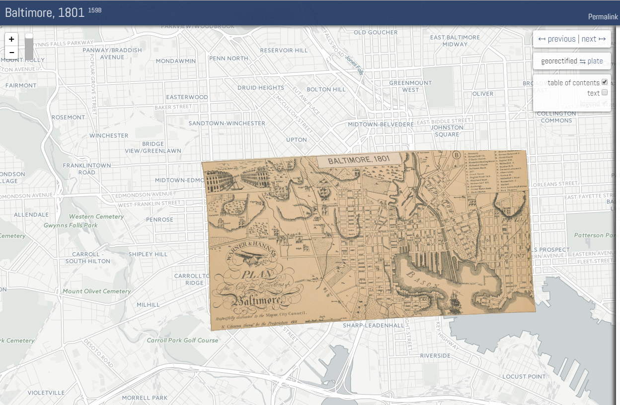
Figure 6, Image of a successful effort at placing the Varlé map into an online GIS environment
Image from http://dsl.richmond.edu/
Until then, the two general views of the City by French trained engineers A. P. Folie and Charles Varlé constituted the only maps available.[8] Charles Varlé’s map, which proved more popular, was included in the early City directories. It is a visually pleasing map that delineates the topography, the approximate location of the streets, and the urban sprawl circa 1801, when the last edition was issued by printers Warner and Hanna. It was useless in helping to determine accurately the existing and future street beds and it provided no indication of the administrative boundaries of the City.[9] What it does demonstrate is that any accurate surveyor would have his work cut out for him. He would have to make sense out of the existing streets on the ground and use the general outline of the existing blocks and streets as shown on the Varlé map as a guide in determining the size and accuracy of blocks. In the future the surveyor who got the job would be criticized for large empty blocks and not taking into account the hilly geography as the City expanded up and out of the tidewater into the hills and dales of the piedmont. That course had already been set before the surveyor got to Baltimore. His task was to accurately delineate on the ground the streets and alleys already there, and to extend them as neatly as possible in the direction they led, which for the most part already determined how large the individual blocks would be.[10]
By 1811, matters had gotten so bad with regard to where the streets actually were and where they were meant to go, including what limits should be placed on how far builders could intrude on their path, that the town leaders, including the legally constituted Commissioners for opening streets, desperately needed a detailed survey and plan to follow. Hence the City Ordinance of March 25, 1812 “for making a correct survey of the City of Baltimore," came to pass, and announcements were placed in the local newspapers soliciting proposals. Under the City charter of 1796, as the most recent definitive political and administrative history of the City by Matthew Crenson points out,
Five City Commissioners were appointed [by the Mayor and City Council] to take over the responsibilities of the five special commissioners for street paving. In addition to the commissioners’ existing responsibilities for paving streets and installing pumps, the new municipal commissioners also had to handle the contentious business of establishing the boundaries of City lots.[11]
It would take a decade until 1822 before the accurate mapping of the City was complete, and not after considerable wrangling, including a not so pleasant competition between a solitary scientific surveyor, and the well-established compass and chain land surveyors of Baltimore City. In the end science won out, but not without an acrimonious struggle.
When Charles Mason and Jeremiah Dixon were hired by the Calverts and the Penns in the 1760s to survey their mutual boundary, no one challenged their methods and praise was heaped upon the results. The accuracy with which they established a degree of latitude and worked from there to run their line westward was a marvel. Their approach was to use the scientific method of surveying called triangulation and a transit (a form of telescope with excellent lenses) that permitted accurate sighting of line and direction.
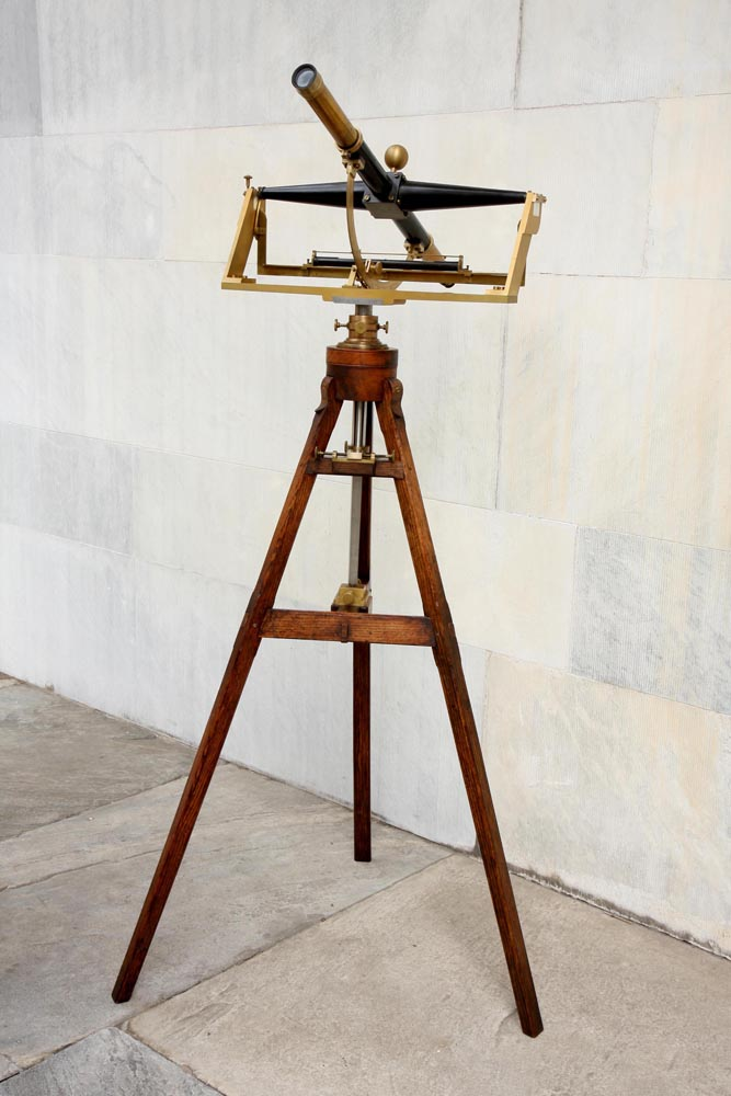
Figure 7, Bird transit used in surveying the Mason Dixon Line, Independence Hall
The instruments and methods they used are illustrated and explained well by Edwin Danson, and the wonderfully restored Bird transit that Mason and Dixon used is now owned by the National Park Service at Independence Hall in Philadelphia.[12]
In 1798 the engineers surveying and laying out Fort McHenry utilized similar methods to Mason and Dixon’s, and what was probably a Ramsden theodolite, a great improvement on the transit, along with trigonometry to perfect their work in surveying the fort.[13]
Local surveyors in Baltimore ignored such advances in accurate surveying and did their best to prevent them being used in laying out the streets and boundaries of the City. That they would do so, probably came as a great shock to a recently arrived 47 year old English surveyor, Thomas Holdsworth Poppleton who was certain his scientific approach was infinitely better.

Figure 8, Saint George in the East, London, where Thomas Holdsworth Poppleton was baptised
Thomas Holdsworth Poppleton was baptised on July 14, 1765 at the Anglican Church of Saint George in the East in London, still in existence at 14 Cannon St Rd London E1 0BH (+44 20 7481 1345). At the age of 15 in 1780 he was apprenticed to a member of the Worshipful Company of Vintners whose motto is Vinum Exhilarat Animum, Latin for Wine Cheers the Spirit. How he got to surveying is not known, although laying out vineyards required considerable surveying skill. Perhaps he enjoyed the products of the vineyards himself along the way, but by the time he died in Baltimore in 1837, he was apparently a teetotalling member of the Methodist Protestant Church on Wilks Street, a church he would highlight in his efforts to map the City.[14]
By January 1799 Poppleton was married to an Ann Firth, of Kippax, York, England, perhaps the same Ann who was forced to open a confectionary shop in Baltimore in the 1830s to supplement her husband’s then meager earnings. Apparently they had only one child, Thomas Holdsworth junior, who probably died as an infant after his baptism in 1805.[15]
By 1805 Thomas Holdsworth Poppleton also had his own apprentice (apprentices had to pay for the privilege the munificent sum of £200 pounds-or about $15,832 in 2016 dollars[16]), set himself up in business as a house, land, and timber surveyor at the somewhat prestigious address of number 1, Bloomsbury Square, London. About the same time, he took on an architect as a partner which proved to be an unmitigated disaster. In 1807 the partnership was dissolved and Poppleton ended up in King’s Bench Prison as a debtor where, eleven years later, another surveyor of geological map fame, William Smith, would be incarcerated for the same reason.[17]

Figure 9, https://en.wikipedia.org/
Fortunately for Poppleton, he arrived in prison just before debtors in Ireland and England were granted a reprieve by King George III and released if they owed less than a thousand pounds.[18]
He remained in the City for brief time, but was pursued by another apprentice who claimed that he had not fulfilled his obligation to train him in the trade. The apprentice describes his problems with his masters in a petition to have his apprenticeship annulled. The court granted his release from the Poppleton and Keeble partnership on the basis that both partners were in hiding (actually both ended up in debtors prison).[19]
Poppleton’s partner, Henry Ashley Keeble would emerge from debtors prison to go on to a modest career as a London Architect (a few of his townhouses are still extant) and even did some work from London for the wealthiest man in America at the time, Philadelphian William Bingham.[20]

Figure 10, Locations of Poppleton’s offices in Baltimore
Thomas Holdsworth Poppleton chose America instead to revive his fortunes, arriving in Baltimore by April of 1812 where he opened an office on North Howard Street, and offered to survey the City in response to a notice soliciting proposals that he had read in the newspapers.

Figure 11, BALTIMORE City BALTIMORE City ARCHIVES
(Baltimore City Commissioners) Administrative files
1812, BRG3-1-16-289[21]
How he came to choose Baltimore to revive his fortunes is not known, but it is possible that he was aware of John Eager Howard’s need for a surveyor of his extensive urban properties, and the City’s desperate need for an accurate survey of its boundaries, streets, and alleyways. The mystery figures in Poppleton’s attraction to Baltimore are the Quaker Assurance broker and friend of the Howards, Joseph Townsend, and Cornelius Howard, Jr., Governor John Eager Howard’s brother.

Figure 12, American and Commercial Daily Advertiser, November 25, 1812
Joseph Townsend, initially a bookbinder and teacher by trade and an opponent of slavery, established the most successful building insurance company in the City (Baltimore Equitable Insurance Society), running it to his and his family’s benefit for over fifty years from the same location on Baltimore Street. He, along with John Eager Howard, was also on the Commission created by the Legislature to oversee the mapping of the expanded City mandated by the Maryland legislature in 1817. He would prove to be Poppleton’s strongest defender and would oversee the completion of Poppleton’s map, paying the bills and lending his young, nearly blind, son, Richard H. Townsend to assist in the task of laying the permanent boundary stones of the City.[22]
Cornelius Howard, Jr., was the brother of Governor John Eager Howard, Revolutionary War hero and friend of Washington’s, who owned significant areas of the City and the surrounding countryside including what was to become Mount Vernon Square and the site of the elegant Robert Mills monument to George Washington.[23] Cornelius was a respected land surveyor of the old school of compass and chain who is probably best remembered as a gentleman farmer and breeder of horses who lived to the ripe old age of 90.[24] In the years before Poppleton, he had been called upon to sort out the ancient surveys of the land that encompassed the City and may even have participated in the abortive 1785 attempt to map the town. The surviving survey notes are among his papers at the Maryland Historical Society.
By 1812, a few years older than Poppleton, Cornelius Howard was well known for his surveys of land in the Illinois country, acting as land agent and surveyor of what would become Rochester, New York for Charles Carroll of Carrollton, and was well regarded as a surveyor by the powers that be in Albany, New York, when he was appointed to a commission to survey canal street in New York City. He would come to Poppleton’s defense. When Poppleton was in effect ridden out of town by a dissenting commissioner and a prominent local land surveyor, Howard recommended him as his own replacement for a prestigious, well-paying assignment in New York City.[25]
On April 10, 1812, from his office on North Howard street, Thomas Holdsworth Poppleton answered the call of the City Commissioners:
In pursuance of a notice date 3rd April which has appeared in the newspapers of this City, inviting proposals for “making a survey and correct plat of the City of Baltimore agreeably to an Ordinance passed 25th March last.” I offer myself to your notice as being disposed to exert my utmost abilities in performing all the duties imposed upon the artist by the above named ordinance….
I beg further to submit that having had much experience in that particular branch of Surveying, I feel myself amply possess’d with the requisite portion of skill.[26]
The requirement of an ‘artist’ surveyor to do the job has puzzled some historians who do not realize that surveying is an art as much as it is a skill, especially when it comes to depicting the product on paper. One of the most important works on surveying published in English (1688 and many subsequent editions in England and America) entitled his work Geodaesia: or, the Art of Surveying….[27] It is likely that Joseph Townsend and the Howards were also aware of the ‘art’ of the surveyor, as well as the obstacles to surveying in an existing City that Richard Horwood faced in the production of his well-known survey of London published between 1792 and 1799.
Horwood intended originally to show every house and its number but this was to prove impossible. Although every house is included the numbering was never completed.
Horwood dedicated this map to the Trustees and Directors of the Phoenix Fire Office, reflecting that the protection of London from fire was at this time the reserve of numerous independent company brigades. The map is coloured, describing parks in green and the London Wall in red. The Tower of London is shown only by outline; Horwood records that: 'The Internal Parts not distinguished being refused permission to take the Survey', evidence that a surveyor was not always welcome.[28]
Poppleton did not propose to show every house, but he did intend the map to be an accurate work of art. He submitted a beautifully drawn hand colored map of the a portion of the city extending southward from John Eager Howard’s estate accompanying his proposal to the city officials which was clearly superior to any mapping of the city done to date, even though it remained to be accurately surveyed.
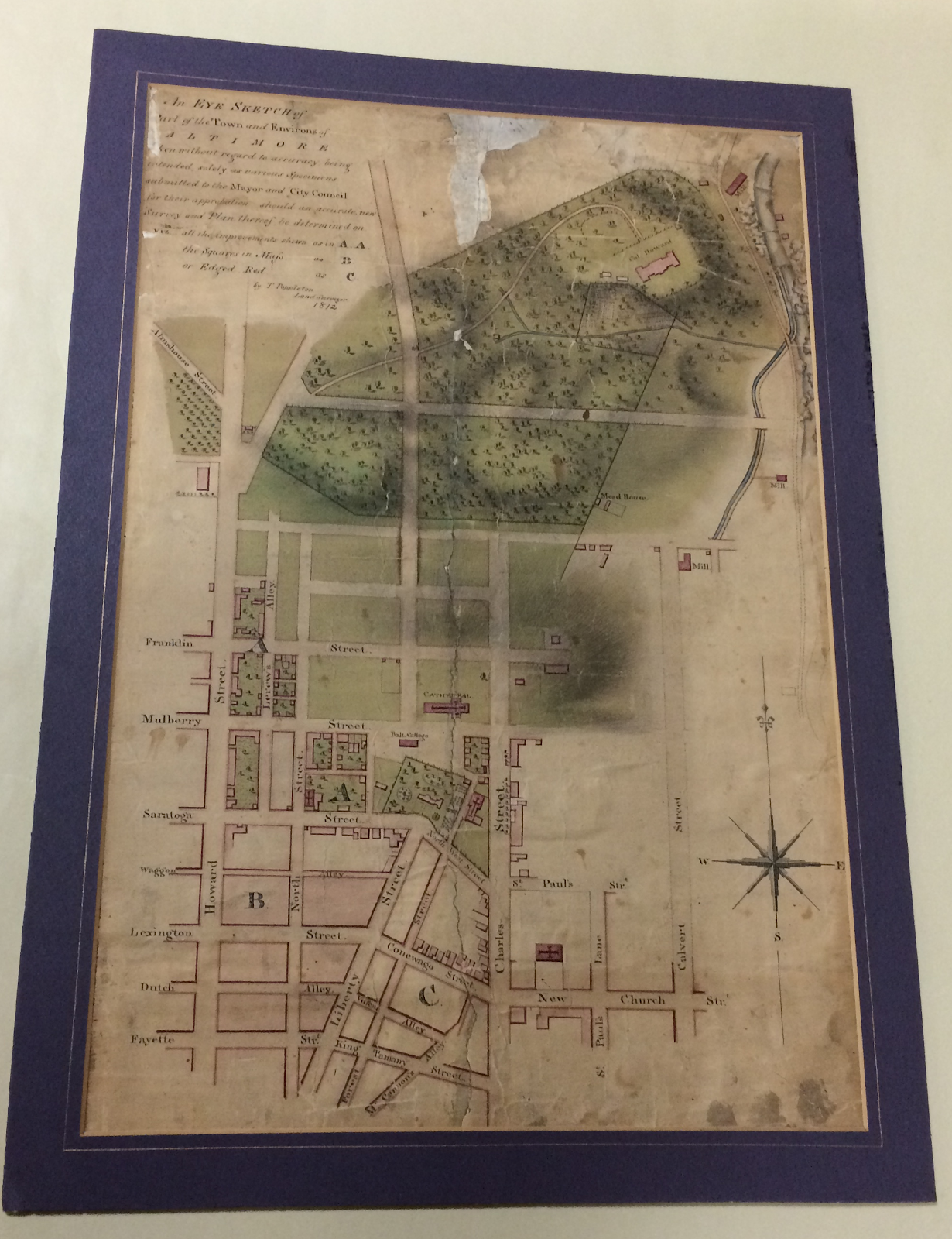
Figure 13, “An EYE SKETCH of Part of the Town and Environs of Baltimore taken without regard to accuracy being intended, solely as various Specimens submitted to the Mayor and city Council for their approbation should an accurate and new Survey and Plan thereof be determined on … T. Poppleton, Land Surveyor, 1812.”
Maryland Historical Society
All but one of the Baltimore City Commissioners supported the adoption of his proposal. From the beginning Commissioner Henry Stouffer, who voted against Poppleton, and his ally Jehu Bouldin, a well-known local compass and chain surveyor set out to undermine Poppleton’s plan. Why is not absolutely certain, except that Bouldin wanted the job, and Stouffer appears to have been an adamant Jeffersonian Democrat/Republican, politically opposed to the Federalist party supported by the Howards.[29]
Poppleton was clearly taken aback by his critics. Hired by the City Commissioners, he began his work and soon found himself tricked into stopping to locate stones marking property lines on streets already laid. Although he complained that it was not a part of his contract and that his job was to say where the boundaries of the City lay on the ground and how the streets should run on the ground in the future according to the laws and ordinances that called for them, he agreed to try to find the boundary between James Carey and former Mayor James Calhoun’s property on Light Street. It proved a disaster for Poppleton. As his enemies put it “Mr. Poppleton not being able to find any point by course and distance for his compass & chain both appearing to be incorrect. …”[30]
Poppleton was livid and wrote a detailed rebuttal to the Commissioners in which he laid out in an eight page memorandum his ardent belief in the reliability of triangulation and the use of a theodolite (possibly a Ramsden) to produce an accurate survey of the town, all the while debunking the old method of compass and chain. He begins by asserting that
If I understand aright, the order for [my] survey [of Baltimore] originated in an idea that I possessed a talent for such an undertaking founded on an improved & scientific method now in general use in civil & military surveying in Europe… [I was] decoyed out, to perform operations with an instrument I condemn [i.e. the compass]-- in a way that is in principal & contrary to my practice… [That] this pitiful underhand mode of proceeding was to be the test of my abilities--to narrow minds it may be apparently correct--from all such I appeal.[31]
He then proceeded to lambast the practice of the compass and chain surveyors, particularly the method used by Jehu Bouldin, although not identifying him by name, and outlining in detail with examples his own.
After explicitly laying out the inadequacies of compass and chain surveying, especially the inability to close a survey and the vagaries of the compass, particularly in an urban setting with its magnetic variations, he detailed his method of triangulation using an instrument of which he was justly proud.
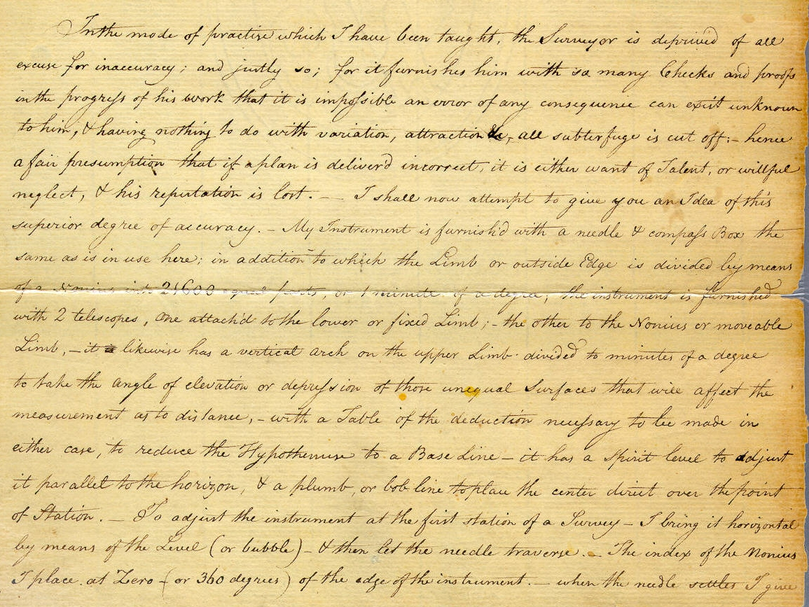

Figure 14, Maryland State Archives, S. J. Martenet Company Collection,
MSA SC 5087-1-1-1/7
What Poppleton describes as his principal instrument for accurate surveying is ironically very close, if not an example, of one favored by Thomas Jefferson and possibly purchased by Jefferson in London in the late 1780s when Poppleton was an apprentice.[32]

Figure 15, https://www.monticello.
That the supporters of Jefferson who dominated the politics of the City in Poppleton’s day cared little about Jefferson’s views on surveying and his preference for the theodolite, if they even knew about them, is understandable. Jefferson was not hailed in Baltimore for his skills as a surveyor, but as the retired President and adamant opponent of the Federal party of Hamilton, Adams, and the Howards, Poppleton’s Baltimore sponsors. Besides, local surveyor Jehu Bouldin thought he knew where the boundary stones of the streets were buried, and felt no need to survey with anything other than a telescope to site a place, a compass to plot direction, and a chain to calculate distance. Indeed, who was this British transplant arriving at the outset of a war with Britain to tell Bouldin and his supporters how to survey?
In closing his assessment of the accuracy of his methods, Poppleton provides a specific example of how his survey of the streets will be more accurate than that of any compass and chain surveyor Commissioner Stouffer puts forth. He begins with the incident that led to his discontent, and the mounting pressure for cancelling his contract, explaining why he could not find the existing boundary stones on Light Street, and concludes with a sketch of his triangulated location of a street corner in Fells Point, across from the Methodist Meeting House on Wilks, near the corner of Apple Alley. It would be a church that Poppleton would feature prominently on his map (labeled no. 1) when at last it would be published for the world to admire, and the City to utilize in its expansion outward.[33]


Figures 16/17, Details from Poppleton’s map of Wilks street with the
Methodist Meeting House identified (no. 1), and survey notes showing the building and his triangulation
at the corner of Apple Alley and Wilks Street in Fell’s Point[34]
The City Commissioners, influenced by Commissioner Henry Stouffer’s skullduggery, and Bouldin’s supporters in City government, backtracked. The mayor, Edward Johnson, who first supported Poppleton, reacted as politicians often do, to Poppleton’s memorandum by suggesting that the City could not afford him (the City Commissioners had agreed to give him $3,000 for his map). In Mayor Johnson’s words:
This Gentleman has addressed a long letter to me, explanatory of his intended mode of procedure, which not embracing the provisions of the law [relating to resolving property line disputes], occasions a special reference to the wisdom & decision of the City Council [to hire Jehu Bouldin as the City Surveyor over Poppleton to carry out those functions].
Observing at the same time, that the expenditure of the sum of three thousand dollars (however anxious we may be to encourage artists of superior talent and abilities) unless it can be made to answer a useful & valuable purpose, is not expedient in the present state of the resources of funds of the City.[35]
In his efforts to unseat Poppleton, Commissioner Henry Stouffer even appealed to Cornelius Howard with regard to evaluating Poppleton’s condemnation of the use of compass and chain surveying. Howard in turn, tactfully as he could, given the political climate, agreed with Poppleton’s assessment of the use of the compass and chain, but the tide had turned against the scientific surveyor. Poppleton quit in disgust in the summer of 1812, as the City became consumed by the advent of war with Great Britain. Surveying the City, except for ideal locations for fortifications, was postponed.[36]
On the strong recommendation of Cornelius Howard, Poppleton, who remained a British Citizen, left for a prestigious surveying assignment in New York City, announcing that if the City fathers wanted all that he had already done, and wished him to complete the survey, all they had to do was to modify his contract, call him back, and leave him in peace to do his work.[37]

Figure 18, Poppleton’s map of lower Manhattan from the New York Public Library Collection, http://digitalcollections.
Harvard College Library has georeferenced Poppleton’s map. See: http://vc.lib.harvard.edu/vc/
It will never be known for certain how the New York legislature came to pick Cornelius Howard to partner with two famous inventors, Eli Whitney and Robert Fulton, in an attempt to contain the open sewer that was known as Canal Street in lower Manhattan. What survives is a copy of a letter of Poppleton’s dated August 13, 1812, from his office on North Howard Street to William Coleman in New York. He informs the fiery anti-war Federalist editor that he will pursue the recommendation of Cornelius Howard, and a wealthy New York Quaker, Thomas Eddy, to replace Howard on the commission to address the problem of Canal Street. Eddy was a strong advocate of a canal through Western New York eventually known as Clinton’s ditch or the Erie Canal. Poppleton told Coleman that he could be in New York in two weeks time, once he finished another legislatively mandated project to survey Pratt Street, the plats for which have survived. William Coleman was the first editor of the The New York Evening Post (today known as the New York Post), chosen by founder Alexander Hamilton, and was outspoken in his opposition to the war against Great Britain. It is possible that Joseph Townsend, Poppleton’s Quaker patron and insurance broker knew Thomas Eddy and instigated his recommendation. Both were successful insurance brokers as well as nationally known Quaker businessmen.[38]
It took longer for Poppleton to reach New York than he planned. His principal contact for the project, Alexander Bleecker, another wealthy New York Federalist whose properties would be affected by the study of options for Canal Street, became anxious, but eventually Poppleton arrived and set up an office in his accommodations. It also took longer for his precious theodolite to arrive, but he did get down to business at once, meeting with his co-commissioners, Robert Fulton and Eli Whitney. While most of Poppleton’s Baltimore papers have long since disappeared, his journal for his first New York project has survived, purchased by the New York Public Library in 1905. In it he details his work with the other two commissioners over the period from October 7, 1812, until all three signed off on their plans and recommendations, submitting them to the City and to Governor Clinton in Albany. Poppleton did the survey and the accompanying plats. Robert Fulton prepared the perspective drawings. Whitney attended all the decision meetings and was consulted on the engineering aspects of the proposed solution to the open sewer that was Canal Street. They began with the idea that they would be proposing a canal with sewers underneath, but concluded that the best treatment was to abandon the canal and concentrate on an elaborate covered sewer. The City fathers found their proposal too expensive and over time all of the drawings and plats have disappeared from the City Surveyor’s office, although their advice was eventually taken. Poppleton’s work was exemplary, however, and landed him the post of one of the City Surveyors, and a partnership with another surveyor that brought him significant business including surveying and mapping parts of Brooklyn. It also provided the the opportunity to produce an excellent survey map of Lower Manhattan, which he published in 1817, one that continued to be used in defining streets and property lines well into the 19th century. By the time his Manhattan map was published Poppleton had an office at no. 8 Wall Street and to all appearances was there to stay.[39]
Back in Baltimore, the political opponents of the Jeffersonian City administration convinced the the 1816/1817 General Assembly to expand the City’s boundaries to encompass the outlying precincts containing the majority voters who were democrats, eliminating their impact on Baltimore County politics. The first act of enlargement left the job to the City Commissioners to lay out the new boundaries, without explicit power of condemning land and naming streets. All the while Jehu Bouldin lobbied hard for the surveying contract.[40]
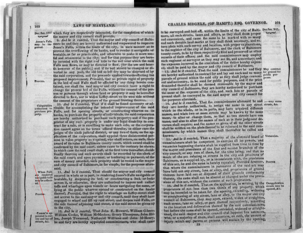
Figure 19, Maryland General Assembly, Session Laws, 1816-1817
Joseph Townsend and his friends in Baltimore were not pleased with the prospects of Jehu Bouldin undertaking the mapping of the City. They approached the Federalist controlled legislature the very next session (1817/1818) and secured new powers to name and layout streets, including powers of condemnation. Under both acts, the City administration was required to pay for the survey and map, but had no control over who did the survey, nor over what methods were used to produce it. The commission, headed by John Eager Howard, with Joseph Townsend and five others, decided to entice Thomas Poppleton to return. He eagerly complied, knowing that with the enhanced powers of the Commission, he would no longer have to contend with a Mayor and the two branches of the City Council.
Townsend supervised Poppleton’s work and advanced the money to pay for it out of Baltimore Equitable Society funds, expecting to be reimbursed by the City upon completion.[41]
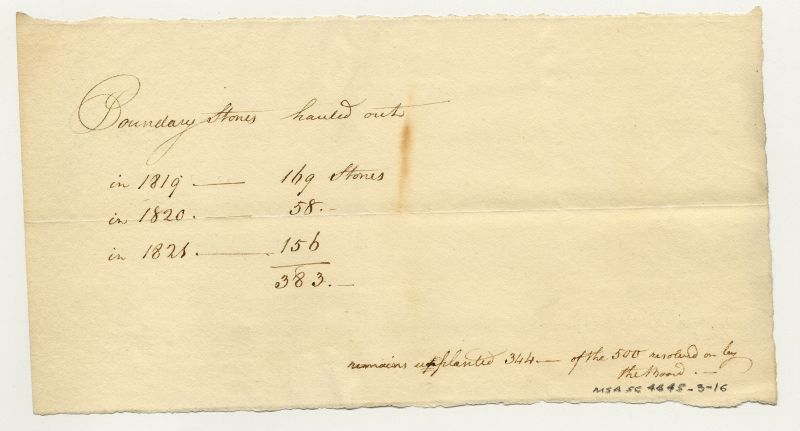
Figure 20, Maryland State Archives Special Collections, MSA SC 4645-3-16
The chronology of Poppleton’s progress on his survey and map survives among the papers of the Baltimore Equitable Society that were purchased at auction by the Maryland State Archives. He commenced his survey and the laying of the perimeter boundary stones in May and June of 1818, apparently uprooting those already planted by Jehu Bouldin. Four years and several hundred stones later the survey was complete, filed with the City, and his derivative wall map was offered for publication by subscription.

Figure 21, Maryland State Archives, Radoff Collection, MSA SC 4645-3-1-23
The map proved to be a work of art as well as an accurate depiction of Baltimore’s streets and blocks as they were in 1822, and as they were meant to be, laid out all the way to the new perimeter of the City. He had to contend with the chaos of existing streets, but straightened and mapped their extensions out as best he could with his trusty theodolite and reliance upon triangulation. What he accomplished lays well upon Google Earth and reflects an accuracy that he promised. The commission had the power to rename streets as the survey progressed, and the map reflected at least two private jokes of the surveyor.
Figure 22, Detail from Poppleton’s Map of Baltimore, 1822, noting the Methodist Meeting House
as the first among the Churches identified on the map
The first was to list the Apple Alley/Wilks Street Methodist Meeting House as the first among Baltimore Churches listed on the map proper, the church location and Wilks street that Poppleton had included as his example of the accuracy of his surveying method. The second was to obliterate the street name, Still-House street, just east of Jones Falls, on which his rival, Jehu Bouldin had long maintained his offices, renaming it a continuation of “Front Street.”
Instead of the original $3,000 that Poppleton proposed as the fee for his services and the resulting map, the project cost nearly $6500 with interest, much of the cost being advanced by Joseph Townsend and Baltimore Equitable. When the bills were submitted to the Mayor and City council for reimbursement, a firestorm erupted over the cost and the quality of the work which emanated from the Stouffer/Bouldin faction on the council.[42]
The reaction of the council was too much for Townsend and Poppleton. The milder response came from Poppleton who published his observations in the local press with a letter to the editor that omitted names found in the original manuscript:
Sir: by the Morning Chronicle of the Tuesday last [March 18, 1822], I learned for the first time at a doubt existed in your Branch of the City Council relative to the correctness of the Plat returned by the Commissioners, and made by me under their direction.[43]
He went on to explain that the issue was the scale used in the map, and that the accompanying plats filed with the City provided both accurate scale and explicit detail.
Joseph Townsend was not as gentle in his scathing letter to the council. The First Branch of the City Council was so taken aback that it recorded in its journal that they returned Townsend’s letter to the second Branch (Where Henry Stouffer’s relative served) with the comment
We beg leave to suggest the propriety of returning it to Mr. Townsend as being a paper unfit to be recorded in the journals of the City Council.[44]
Townsend had a right to be angry. Poppleton did what he said he would and produced a map that the City came to adopt as its own, with an amended edition in the early 1850s that was used for Baltimore’s unique system of land transfer and recordation, the block book system, whereby Poppleton’s City blocks were numbered on his map and all recorded land transaction from 1851 forward were recorded geographically by block.
Unfortunately over time the block book system broke down through poor administration by the court of record and the City, but for the rest of the nineteenth century until well into the twentieth it served surveyors and the public admirably. Recently it was supplanted altogether by an automated on-line automation of land recordation created by the Maryland State Archives that placed the surviving blockbooks and the related recordations on line making title searches for lot descriptions infinitely easier for developers and their surveyors, although the nightmare of ownership and title entangled in ground rents has not been effectively addressed and remains a thorn in the side of re-development of the streetscapes of the City. Baltimore like Birmingham in England used the leasing of property at interest (ground rents) to free capital for building on the property. As long as the ground rent was paid the buildings could be separately bought and sold. If it wasn’t, technically anything on the property reverted to the property owner. Over the years the ownership of the ground rents and the above ground property owners became a quagmire of who owned what. In some instances ground rents were being double charged because of overlooking property divisions within estates to the point that some property owners in a block, instead of being charged with half the ground rent for the block, were each charged the ground rent for the whole block. The Legislature once again tried to act in what it perceived the best interest of the City and tried to abolish ground rents altogether by legislative fiat. In 2014, the Maryland Court of Appeals found the law unconstitutional and the mess remains.[45]
Figure 23, Plates from Thomas Poppleton’s survey of the John Eager Howard Estate,
Maryland State Archives, MSA S512-8804
In the years after 1822, Poppleton did not have to worry about ground rents in his surveys. Instead he helped create them, particularly with the work he did in surveying the John Eager Howard estate. When Howard’s daughter contested the division of her father’s estate, by another act of the Legislature intended to resolve the differences, Thomas Poppleton was hired to survey and lay out a fair distribution with clearly defined streets including the Mount Vernon Square district that is today the home of Robert Mill’s monument to George Washington.[46]
Little of Poppleton’s post 1822 survey work has survived in print, save elevations for a proposed canal and a reduced copy of his B & O survey[47]
Poppleton did participate in the enthusiasm for canals to improve the City’s prospects for trade. He surveyed the elevations and path for a proposed canal from the Susquehanna to Baltimore for which Fielding Lucas, a local printer of fine maps ultimately drew upon for the copies now located in the Maryland and Pennsylvania Archives.[48]
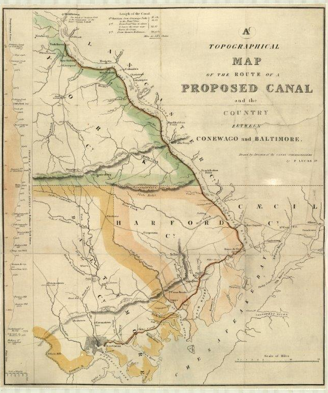
Figure 24, The Pennsylvania State Archives, MG 11-Map Collection, 156. A Topographical Map of the Route of a Proposed Canal and the Country Between Conewago and Baltimore. Drawn by direction of the Canal Commissioners by F. Lucas, Jr. Shows: length of canal, profile of Mr. Poppleton's series of levels from Baltimore to York Haven, n.d. Printed, in 4 colors. Laminated, 1 section
By 1830, he had been forced to apply for relief under the bankruptcy law of Maryland which required him to apply for citizenship, where he was sponsored by his longtime friend and patron, Joseph Townsend.[49] The next year his fortunes appeared to improve. He went on to work for the B&O Railroad and mapped its efforts to construct a main line on Pratt Street.[50]

Figure 25, A reduced version of Poppleton’s survey for the Baltimore & Ohio Railroad
While his efforts to survey for the B&O were praised in the press, the original surveys have disappeared save for the reduced version that appeared in a B & O report. Poppleton Street that runs along one edge of the Mount Clare Station and B&O roundhouse, survives, however, just as he indicated on his 1822 map. It is not often, if ever, that a surveyor is able to name a street after himself, but why not? Surely he deserved it.

Figure 26, Detail from the 1851 revision of Poppleton’s map showing Poppleton Street, upper right
Maryland State Archives copy, MSA SC 1427-1-582
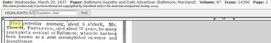
Figure 27, Thomas Poppleton’s death notice, Baltimore Gazaette, March 29, 1837
Poppleton’s last years were spent in apparent near poverty. When he died of ‘old age’ at 72 in 1837, there were no surviving children. Only brief notice was made of his passing. By then his wife Ann had opened a confectionary shop as a means of support, and at his death there was not enough property for her to inventory and distribute as his administrator.[51]


Figure 28, From the Baltimore Sun, June 9, 1912, vertical file, Enoch Pratt Free Library, courtesy of Joel Leininger
What happened to Poppleton’s treasured theodolite and the bulk of his papers is unknown, although it appears that the Bouldin family acquired some, including the original of his plat of Pratt Street that he completed in 1818. Indeed by 1912, Jehu Bouldin’s granddaughters suggested they owned Poppleton’s theodolite, a picture of which was published in the Sun. It wasn’t. Instead it was a later model probably used by their father, Alexander Bouldin, who came to adopt Poppleton’s approach to surveying. The irony remains that the family would appear to think so highly of the memory of Poppleton by 1912, but his instrument remains at large, if not lost altogether.[52]
Anyone interested in plotting the history, growth and development of Baltimore from 1822 to the present cannot escape admiring and utilizing Thomas Poppleton’s survey map of the City.
It places well on the existing streets of Google Earth and can be used to aid in the geo referencing of the physical change of the City over time as well as the history of the homes, institutions, and businesses it locates and identifies.
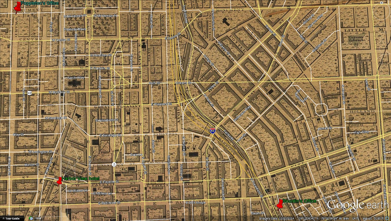
Figure 29, Poppleton’s 1822 map placed on top of Google Earth with current streets shown in white and yellow. Poppleton’s office in 1822 is marked in the upper right corner and Jehu Bouldin’s near the bottom right
Around its border are inset illustrations of public monuments, fountains, churches, banks and businesses as of 1822, with historical images at its base of the first images and layout of the the town, and the bombardment of Fort McHenry whose battlements had been placed with aid of another theodolite a decade and half before Thomas Holdsworth Poppleton came to town to battle his land surveyor peers over how best to measure and delineate the City streets. [53]

Figure 30, 1852 revised edition of Poppleton’s map,
first published in November of 1851,
Maryland State Archives copy, MSA SC 1427-1-582[54]
A decade and a half after Thomas Poppleton’s death, his map and building vignettes along the borders were updated, and used by the City for a geographical recordation system unique among Maryland jurisdictions, that recorded land transactions by his City blocks which by 1886 numbered 2073.
In the end Poppleton’s map triumphed as the base map upon which all future development of the City was directed. His was indeed The Map that Made Baltimore. May his reputation regain some of the lustre it deserves in the grand tradition of such scientific surveyors as Charles Mason and Jeremiah Dixon, and the unheralded surveyors of Fort McHenry.[55]
[1] Edward C. Papenfuse, Archivist of Maryland from 1975 to 2013, has written extensively on the history of Maryland and Baltimore City. All of the maps illustrated here were imaged and placed in their historical context in Edward C. Papenfuse, and Joseph M. Coale, The Maryland State Archives Atlas of Historical Maps of Maryland, 1608-1908. Baltimore, Md: Johns Hopkins University Press, 2003, which was the greatly expanded edition of Edward C. Papenfuse and Joseph M. Coale. The Hammond-Harwood House Atlas of Historical Maps of Maryland, 1608-1908. Baltimore, Md: John Hopkins Univ. Press, 1982. For an assessment of the maps and plats relating to Baltimore City see: Richard J. Cox, “Trouble on the Chain Gang: City Surveying, Maps, and the Absence of Urban Planning in Baltimore 1730-1823; With a Checklist of Maps of the Period,” Maryland Historical Magazine, Volume 81, No. 1, Spring 1986. Cox provides a comprehensive list of known mapping of the City, but he does not always ascribe authorship accurately.
[2] Efforts had been made as early as 1773 to merge the three areas into one jurisdiction. For the story of this attempt see the first two chapters of Suzanne Ellery Greene, An Illustrated History of Baltimore, 1980. The earliest known printed version of Poppleton’s wall map is dated 1821 and is in terrible, but stabilized, condition at the Maryland State Archives. It probably is a proof copy that was retained by the Baltimore Equitable Assurance Company. It was acquired by the Maryland State Archives from the auction of the archives of the Baltimore Equitable Assurance Company. The wall map was advertised for sale in 1822.
[3] For the charter and description of the three united communities into Baltimore City see; Baltimore (Md.), and Samuel Young. Ordinances of the Corporation of the City of Baltimore: With the Act of Incorporation, and the Several Supplements Thereto : to Which Is Added, an Appendix, Containing an Abridgement of, and References to, All Such Acts of the State Legislature of Maryland, As Relate to the Boundaries, Police and Regulation of Baltimore, Before or Since Its Being Incorporated : with a Copious Index to the Whole. Baltimore: Printed by William Warner, 1816.
[4] See the text of the law at: http://aomol.msa.maryland.gov/
[5] Head, David. Privateers of the Americas: Spanish American Privateering from the United States and the Influence of Geopolitics in the Early Republic. 2015, and Sherry H. Olson, H. Baltimore, the Building of an American City. Baltimore: Johns Hopkins University Press, 1980. For the panic of 1819 and its aftermath see: Edward Papenfuse, Baltimore: October 1816 A City of Promise on the Bay, and Garrett Power, Baltimore After the War of 1812: Where Robert Mills met his Waterloo and When James A. Buchanan Broke the Bank. See also: Baltimore: October 1816, A City of Promise at: http://1814baltimore.blogspot.
[6] Ordinances of the Corporation of the City of Baltimore from 1803 to 1812, inclusive, Baltimore: John Cox, 1876, pp. 329-330, no. 28, adopted March 25, 1812.
[7] Maryland Historical Society, Cornelius Howard Papers 1659-1853, MS. 469.5, Box 2, Field Notes of a Survey of a Part of Baltimore Town (1 vol.), 1785-86. Howard’s papers contain the survey notebooks for 1727-1730, of Philip Jones, Jr., Deputy Surveyor for Baltimore County, as well as considerable detail on Howard’s surveying career. Cornelius Howard became a good friend of Poppleton’s and did what he could to advance Poppleton’s career.
[8] For Charles Varlé, a refugee from the revolution in Haiti, see: 1814: A Plea for Better Privies and a Cleaner life-Baltimore's Forgotten Civil Engineer and Map Maker, Peter Charles Varlé, http://1814baltimore.blogspot.
[9]The University of Richmond has geo-referenced the 1801 edition of Varlé’s map at Permalink: http://dsl.richmond.edu/
[10] Sherry Olson, Baltimore, 1980, pp. 57-58, would become the chief critic of the consequences of Poppleton’s map:
The standard Baltimore block that Poppleton selected differed from New York, and his hierarchy of street widths—front, side, and alley—created a pattern for future construction and for differentials in social structure that persist to this day. Poppleton's solutions for stitching together the several pre existing street grids along the seams of through streets produced the modern traffic engineer's nightmare and the pedestrian citizen's delight. Dozens Baltimore streets jogged, or met in intersections of five streets. A street vista was often visually closed by an angled terrace, a steeple, chimney, or turret.
Sometimes triangular points of land were left, better suited to a statue, fountain, or garden than a house. The chief limitations of the plan stemmed from the fact that it was not a topographical survey. In order to save money, topographical survey was rejected, and the final plan was two dimensional. Its "striking regularity" was achieved at the cost of ignoring variations of terrain. This feature, too, contributed to the character of inner-City Baltimore: straight rows of houses step up and down the hills, and vistas surprise the driver at each rise or dip. But much of the costly bridging, filling, tunneling, storm sewering, and regrading for a century must be attributed to a cavalier attitude toward the relief. A two dimensional plot, as some citizens realized at the time, would not produce order in the hydrologic system, correct the nuisances, or minimize future public investments. It did, however, make possible the continuation of subdivision and private speculative development. Ads began appearing immediately that suggest why the plot met with the "entire approbation" of all the large landowners. Christian Mayer's estate was offered for sale: "In the late plan of the City a public square is laid out on it, with Baltimore street extended running through the estate, with a front of about 240 feet." Part of Edward Ireland's estate was subdivided along the newly plotted Chatsworth Street front. City planning of this kind was an essential tool for efficiency in the private exploitation of urban land. Public control of the proper sort stimulated the speculative system. Facilitating the circulation of money took precedence over facilitating the circulation of water. The contradictions were glaring. The means of developing and controlling the physical environment increased, yet, as I have shown, environmental problems loomed larger than before. The same thing was happening in the social environment: the resources were greater, but so were the disharmonies. The dimensions of poverty seemed to increase. Like smallpox and yellow fever, violence threatened to break into mob rule or anarchy. Everyone saw the visible signs of success and failure all around, and everyone experienced the pressures of boom and collapse. For the rich and the poor, both vulnerable, these experiences intensified the sense of disorder and produced a yearning for order. Each struggled in his own way to make sense of his world.
[11] from the manuscript to Mobtown Or Charm City?: Race, Politics, and History in Baltimore, by Matthew A. Crenson, Baltimore: Johns Hopkins University Press, 2017, ISBN 1421422069, 9781421422060
[12] Danson, Edwin. From the Post Mark'd West: The Making of the Mason-Dixon Line. New York: John Wiley, 2001. For the restoration of the Bird transit see: http://www.
[14] London Metropolitan Archives, Saint George in the East, Register of baptisms, Oct 1749-Dec 1770. P93/GEO/002, available on http/ancestry.com. London Apprenticeship Abstracts on http://search.findmypast.com/
[15] “England Marriages, 1538-1973,” database, FamilySearch (https://familysearch.org/ark:
[16] Converted using http://www.uwyo.edu/numimage/
[17] The London career of Thomas Holdsworth Poppleton and his partner Henry Keeble can be traced in the London Gazette which is online at https://www.thegazette.co.uk, especially 24 April 1804, 28 July 1804, 20 June 1807, and the London City directories which are not on line and were consulted on microfiche at the London Metropolitan Archives. Poppleton’s stay in King’s bench prison is documented in the “London, England, King’s Bench and Fleet Prison Discharge books and Prisoner Lists, 1734-1862” which are indexed and accessible on http://ancestry.com. For William Smith, the famous cartographer who created the most important geological map of England and also ended up in debtor’s prison, see Simon Winchester. The Map That Changed the World: A Tale of Rocks, Ruin and Redemption. London: Penguin, 2002.
[18] How to deal with debtors and bankruptcy is a complicated story in Britain and the United States. In Poppleton’s day in England there was considerable agitation for reform of the laws relating to bankruptcy and pressure was brought in Parliament to provide relief to those debtors who were in prison, Poppleton among them. The law that released him was enacted on June 19, 1809 entitled “An Act for the Relief of Certain Insolvent Debtors” which begins “Whereas it may be convenient in the present crowded State of the Prisons and Gaols in England and Wales, that some of the Prisoners confined therein, truly surrendering their Effects to the Creditors, should be liberated …” Original printing of the act in the author’s possession. According to one summary account, Poppleton would have been one of 15 prisoners incarcerated in King’s Bench who were freed under this act. James Neild, An Account of the Rise, Progress, and Present State of the Society for the Discharge and Relief of Persons Imprisoned for small debts throughout England and Wales, London, 1808, p. 581.
[19]The details of this case are to be found in the Middlesex Sessions of the Peace records, papers for 1809 June Quarter Sessions, Petitions and Appeals, George Imms, apprentice, v Thomas Holdsworth Poppleton and Henry Ashley Keeble, late of Bloomsbury Square, ...., in the London Metropolitan Archives, labeled MJSP/1809/06/01.
[20] For what else is known of Henry Ashley Keeble’s career including his design for William Bingham’s gate see Howard Colvin, A Biographical Dictionary of British Architects, 1600-1840. New Haven: Published for the Paul Mellon Centre for Studies in British Art by Yale University Press, 1995.
[21] This image of BRG3-1-16-289 is taken from scans of the original. See: http://msa.maryland.gov/
[22]Joseph Townsend deserves a biographer. Two promising scholars have been working on the story of his life, James Bigwood (see: http://www.findagrave.com/cgi-
[23] For a brief biography of John Eager Howard see; http://msa.maryland.gov/msa/
[24] Commercial Advertiser (New York, New York), Tuesday,February 27, 1844, “On the 12th inst. At his residence in Baltimore County, Md., Cornelius Howard, Esq. in the 90th year of his age.”
[25] Maryland Historical Society, Cornelius Howard Papers 1659-1853, MS. 469.5, and an item in William Reese Co., catalog, 331: Carroll, Charles: [RETAINED COPY OF AN AUTOGRAPH LETTER, SIGNED, FROM CHARLES CARROLL OF CARROLLTON TO CORNELIUS HOWARD, CONCERNING THE SALE OF SOME LAND]. Annapolis. Dec. 23, 1789. [2]pp. Quarto. Old fold lines. Some light chipping and wear. About very good, which in part reads: “Sir, I should be glad to be informed whether you have made any progress towards completing the survey of Rochester, and whether you have sold any more parcels of land out of that tract, and to whom, and on what terms. Be pleased to furnish me with a list of the person's names to whom sold, if you have sold any land, since I saw you in Baltimore town, setting down in said list ye price p. an. & quantity of acres sold to each. I request you will receive for me the rent & arrears of rent of the man, who formerly paid Richd. Ridgeley....I wish also to be informed whether you have sold to Mr. Owings, the land which Macklefresh had agreed to buy of Richd. Ridgeley. I request you will receive for me of the persons underneath mentioned the respective sums due from each of them for a year's interest, and your receipt for the same shall be good against.” The letter
[26] See: http://msa.maryland.gov/
[27] Love, John, Geodaesia: or, The Art of Surveying and Measuring of Land Made Easie. . As also How to Lay out New Lands in America, or Elsewhere:…, (London, 1688), xxii, 196, 52 . Love published his first edition after returning from surveying in America. He was particularly concerned about the lack of knowledge exhibited by young surveyors in Carolina. Later editions of the book appeared for over a century with the 12th (1793) and 13th (1796) editions being published in New York. The work changed little over the years, even considering the later revisions of Samuel Clark. Instructions are given in use of a Gunter chain and measuring angles with the circumferentor, plane table, and semicircle. There are also directions for taking field notes and measuring and calculating the acreage for plots of land. George Washington (1732-1799) studied surveying from Love's Geodaesia which was widely used in America. .
[28] Quoted from: http://www.bl.uk/
[29] The documentation for the discussion of Poppleton’s relationship with the City Commissioners in 1812 and the specific quotes as noted are taken from the e-publication of the records in the Baltimore City Archives available at: http://msa.maryland.gov/
[30] Ibid.
[31] Ibid.
[33] The 1819 City directory lists a church at Apple Alley as African American. The location of this church is not clear. The church near the corner of Apple and Wilks is not subsequently identified as African in the City directories. While Mistress Auld attended class meeting at the Wilk street meeting house, Frederick Douglass stayed at home alone, learning to write. See: Douglass, Frederick, and Henry Louis Gates. Autobiographies: Narrative of the Life of Frederick Douglass, an American Slave ; My Bondage and My Freedom ; Life and Times of Frederick Douglass. 1994, p. 45.
[34] Poppleton’s lengthy explanation of his surveying technique and his criticism of the then current method of land surveying is reproduced in Edward C. Papenfuse and Joseph M. Coale, The Maryland State Archives Atlas of Historical Maps of Maryland, 1608-1908. Baltimore, Md: Johns Hopkins University Press, 2003, p. 172, and are found in the S. J. Martenet Company Collection, MSA SC 5087-1-1-1/7.
[35] Mayor Edward Johnson to the First Branch of the City Council, May 26, 1812, on line at: http://msa.maryland.gov/
[36] The whole controversy is detailed in the papers of the City Council and Mayor’s office that were inventoried by the WPA in the late 1930s. Some of the papers were scanned and placed on line beginning at: http://msa.maryland.gov/
BALTIMORE City ARCHIVES, (Baltimore City Commissioners) Administrative files, 1812, BRG3-1-16, in the Maryland State Archives Guide to Government Records: http://guide.msa.maryland.gov/
[37] Ibid. The documentation for Poppleton’s work in New York and his replacing Cornelius Howard as a Commissioner appointed in the Act for the appointment of Commissioners to ascertain the best method of conveying off the Waters from the Collect and Lispenard’s Meadow, in the City of New York, passed June 19, 1812 (see; Laws of the State of New York passed at the Thirty-fifth Session of the Legislature …, Albany, 1812, p. 419), is to be found in the Thomas Poppleton Papers, 1812-13, MssCol 4582, of the New York Public Library, Manuscripts and Archives Division, a digital copy of which was purchased by the author. See also The Iconography of Manhattan Island, vol 5, New York: 1926, for a number of references to Thomas Poppleton at work in New York. The most accessible copy is on line at: https://archive.org/details/
[38] Ibid. For Eddy see: https://en.wikipedia.org/wiki/
[39] Minutes of the Common Council of the City of New York…, v. 9, 1817-1818, p. 279, and Thomas Poppleton Papers, 1812-13, MssCol 4582, of the New York Public Library, Manuscripts and Archives Division.
[40] Jehu Bouldin’s proposal to survey the City was announced in the Baltimore Patriot, February 11, 1818.
[41] Maryland State Archives, Radoff Collection, MSA SC 4645-3-1. Sadly almost all of the original Poppleton survey plats no longer exist, with the exception of a portion of the proposed extension of Pratt Street over the existing wharves, dated May 1818, Baltimore City Archives, BRG 12-s3-66.
[42] The controversy is documented in the minutes of both branches of the Baltimore City Council, which are on line through the Baltimore City Archives. See: https://baltimoreCityhistory.
[43] Baltimore American & Commercial Daily Advertiser, April 3, 1822.
[44] Baltimore American & Commercial Daily Advertiser, March 27, 1822.
[46] Maryland State Archives, MSA S512-8804.
[47] It is possible that other Poppleton surveys will be found among the equity records of Baltimore City and the State Chancery Court, but to find them would entail a long and arduous search until those records are scanned and placed on line.
[48] The Pennsylvania State Archives, MG 11-Map Collection, 156. A Topographical Map of the Route of a Proposed Canal and the Country Between Conewago and Baltimore. Drawn by direction of the Canal Commissioners by F. Lucas, Jr. Shows: length of canal, profile of Mr. Poppleton's series of levels from Baltimore to York Haven, n.d. Printed, in 4 colors. Laminated, 1 section
[49] Baltimore Gazette and Daily Advertiser, December 4, 1830, and Baltimore County Court (Naturalization Docket) Declaration of Intent of Thomas Holdsworth Poppleton, 7 July 1830, Volume 1, p. 161, Maryland State Archives, MSA C389-1. The bankruptcy proceedings cannot be located and there is no evidence that Poppleton completed the naturalization process.
[50] Baltimore Gazette and Daily Advertiser, February 8, 1831.
[51] Maryland State Archives, Baltimore City Archives Record Group, BRG19-1-8-6, Report of Interments in the City of Baltimore, April 3, 1837, documenting burial in the Protestant Methodist burial ground.. See the Baltimore City Directory for 1831, where Thos Poppleton, Surveyor, has an office on Hill st. w of Light and Mrs T. H. Poppleton is a confectioner at 4 North Calvert Street. Letters of administration were granted to Ann Poppleton with John Beary and Robert Skillman as sureties on November 30, 1837. There was no will and no inventory taken which indicates that there was nothing of value in his estate. See Baltimore County Administrations, 1835-1840, vol. 10 at http://familysearch.org.
[52] From the Baltimore Sun, June 9, 1912, vertical file, Enoch Pratt Free Library, courtesy of Joel Leininger,.
[53] The art of Poppleton’s map is in the quality of its execution and the images of the architecture of the City which surrounds it. Through the two editions and on the Klemm derivative, the buildings of 1822 were replaced by newer structures (6 between 1822 and 1852). Jeremy Kargon has written about the vignettes of buildings that surround the Poppleton and Klemm maps in an article for the Maryland Historical Magazine, Volume 104, no. 2 (Summer 2009), pp 185-207, and as a word document on line entitled A Closer Look at Poppleton’s Map of Baltimore Thirty-Seven Vignettes of a City’s Self-Image, without illustrations at: http://www.jkargon-architect.
[54] Boston Rare Maps recently sold a first edition of this map that they thought was the second edition: T[homas] H. Poppleton (mapmaker) / [Charles P. Harrison (map engraver)] / J. Cone (engraver of vignettes) / Updated by William Sides, Surveyor and republished by Isaac Simmons, THIS PLAN OF The City of Baltimore as enlarged & laid out by T.H.POPPLETON under the direction of the Commissioners APPOINTED BY THE GENERAL Assembly OF MARYLAND IN FEBY. 1818…, Baltimore, [1823] / November 1851. Engraving on four sheets joined, 44.25"h x 57"w plus margins, outline and wash color. Mounted on modern replacement linen.
[55] From its publication in 1822 until the Bromley atlas in 1896, Thomas Poppleton’s map remained the standard reference map for the City. The Lucas maps were copies as were those published in the city directories. In fact, when the block-book system of recording property transfers was instituted in 1851, Poppleton’s updated map was used as a base map on which block numbers were assigned. In 1894 L. M. Duvall explained the new method in his Practical Points for Conveyancers, a. volume that still remains useful for anyone searching City land records. Duvall noted that by 1886 the City was divided into 2073 blocks, or squares (Poppletons Map being used for the purpose). Each of these blocks or squares is bounded by well-defined streets and each is given a number. . . . The index books each contain a certain number of pages, numbered to correspond with the block numbers on the map. L. M. Duvall, Practical Points for Conveyancers (Baltimore, 1894), p. 9. In 1897 the City published the results of a detailed topographical survey conducted between 1894 and 1896. It consisted of thirty-seven plates prepared under the direction of H. T. Douglas, Chief Engineer, City of Baltimore Topographical Survey. The Sanborn and Bromley atlases were more manageable in size and more widely used by banks, real estate agents, and tax assessors. For on line copies of the Sanborn and Bromley atlases see and e-publication by the author: http://www.mdhistory.net/